
As with many of my best adventures, this one began with an invitation from one of my children. In this case, the invitation came on the heels of a situation that would foreshadow events to come.
It was Thursday, July 30, 2020, just before 11 AM EDT. I was at work. My phone lit up with text messages from my oldest daughter, Katrina, who was in the middle of a solo hike of the Pacific Crest Trail.
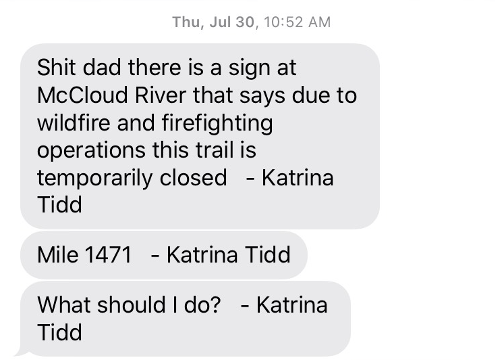
The fact that Katrina’s name was appended to each message told me she had sent the messages from her InReach satellite communicator. This meant that she didn’t have cell reception where she was. Her second message gave me the distance she was from the Mexican border, according to the Guthook app.
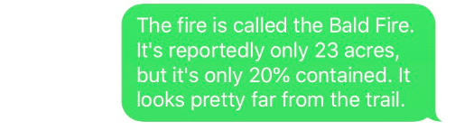
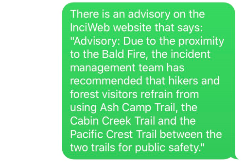
I responded that I would look into it. I looked up her location on Guthook and then began searching the internet for details on the fire. I found some information and texted it to her:
In short, officials were recommending that hikers stay off the section of the PCT that Katrina was about to hike. A frenzy of messages ensued:
Nico (Nicola), Katrina’s fiancée, was planning to meet her the following day. Katrina was messaging him separately and had him working the problem too. I messaged Katrina and let her know I would try to find answers to her questions and get back to her.
What to do was a real dilemma for Katrina. She was hiking the trail in the purist style. As such, she was attempting to hike the entire, official PCT without skipping any sections or taking any alternate routes, while following all the rules and regulations along the way. So far, she had been able to do this despite the ongoing pandemic and the governmental restrictions related to it.
For example, Katrina’s PCT permit specified that she had to start her hike at the Mexico border on May 9th, but coming up to this date, California’s COVID restrictions did not allow outdoor recreation. Then, on May 8th, the day before Katrina was scheduled to start her hike, California relaxed its restrictions to allow travel for outdoor recreation.
Similarly, at the start of her hike, many sections of the PCT (e.g., in Yosemite National Park) were closed, but the trail closures were all lifted before she reached them.
Here, however, at mile 1471, she had hit an obstacle. She could skip this section of the trail, or hike the roads around it, or she could ignore the closure sign and hike through it. Katrina decided to start hiking toward the fire while Nico and I worked to answer her questions.
I texted Katrina answers to her questions. I told her the fire was about 12 miles to the west of her and that it looked like the closest the fire came to the PCT was about 3 miles.
Then, in the pattern that had repeated itself many times on her hike, the Red Sea parted and let her through: The advisory on the InciWeb website was lifted, and the trail was reopened.
I texted Katrina the good news:
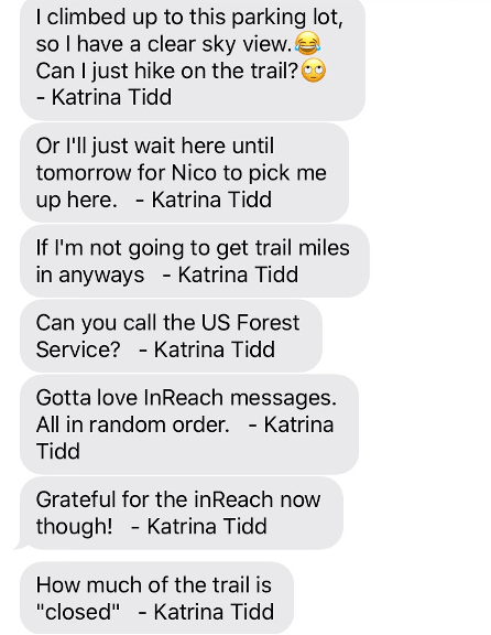
In one of her earlier messages, Katrina had noted one of the weaknesses of the InReach: namely, that it has a tendency to deliver messages out of order. Another limitation is it can’t send or receive messages if you don’t have a clear view of the sky. These limitations can lead to communication failures, which can be upsetting in stressful situations, and dangerous in emergencies. The InReach is an amazing piece of technology, but like everything, it is subject to Murphy’s Law. As such, there is a good chance that when you really need it to work, you will find yourself in dense forest on the north side of a mountain, unable to send or receive messages. Katrina was now in such a place, and she did not receive my message or the details I sent her on the fire. My next messages from her were:
I tried again:

Still no luck. Katrina’s frustration level was rising:

Then, Nico’s messages made it to her:
Dang, Nico beat me to it!
Then, Katrina finally received my messages:
![]()
And then, a while later…

Whoa, new topic. Katrina was apparently probing to see if I was available to join her on the trail or assist in some way. At work, I was in the final throes of completing a major upgrade of the software product that I have spent my career developing. The new version was horribly behind schedule, and there was huge pressure to get it done. It was slated to be released within a few weeks. It was hard to me to imagine a worse time to be away from work.
But this was nothing new. I had spent too much time working when Katrina was growing up, and I had missed out on a lot. I wasn’t going to miss out on this. I texted her back:

She responded:
Haha. Silly question.
Day 0 – August 10th – ~10 miles
Eleven days later, I was on a flight to Medford, OR. I had arranged to meet Katrina near where the PCT crosses the California-Oregon State Line at around 6 PM.
There are no major roads near where the PCT crosses the CA-OR State Line, but there is a nice gravel forest service road that crosses the PCT 0.3 miles from the state line, on the Oregon side. I had found a taxi company willing to drive me there. Google Maps showed that the Pacific Crest Trail – Stateline Trailhead was about 40 miles and 90 minutes from the Medford Airport.
When I arrived in Medford, my taxi, a Subaru Outback, was waiting. The driver was a very nice woman who had grown up in Medford, lived in Alaska for a while, and then moved back to Medford. We made a quick stop at a store so I could buy some water, and then we started heading toward the state line.
The driver was using Google Maps, but it wasn’t taking us in the direction my phone was showing. It turned out she didn’t have the correct destination entered in her phone. We got that straightened out and got going in the right direction.
As we were heading out of town, it began to sink in that I was going to have to do the navigating, and that there was unlikely to be any cell service on much of the route. I tried to download offline maps, but I had waited too long. There was already no service. Google Maps was still able to direct us, but it was only showing the detail of the route that had already been downloaded.
We turned onto the first dirt road. I started taking notes at each of the turns so the driver would be able to find her way back. The roads got smaller and rougher at each turn. I started having my doubts when Google had us turn onto a steep road with big rocks and ruts. It was about here I realized that, while I had checked out the quality of the road near the state line on Google Maps’ satellite view, I had not checked out all the roads along the route.
We rounded a corner, and it was immediately clear the Outback was not going any farther. The road was too steep and rutted. My stock Jeep would have had trouble getting up the hill ahead. We were about 10 miles from the state line, but my hike was going to start right here.
I settled up with the driver and gave her instructions on how to get back to the paved road. Then, I shouldered my pack and started hiking. It was 4 PM.
I got out my InReach satellite communicator and tried to message Katrina that I was going to be late. During her hike, I had been messaging Katrina on her InReach from my phone, but I couldn’t use my phone now because there was no cell service. You can send messages from one InReach to another, but you have to know the address of the recipient’s device. I thought I knew Katrina’s address, but I had never sent her a message from my InReach, so I wasn’t sure I had the right address.
As I was worrying about whether Katrina had received my message, I came to a junction with a larger dirt road. It wasn’t obvious which way I should go from the limited data I had on Google Maps. I turned, right. After about a quarter mile, the road turned west, taking me away from the Google Maps route. There was another road that headed in roughly in the right direction (South), so I took that.
After a while, it was clear that I was not on the right road. The road I was on was taking me parallel to the road I was supposed to be on, but I was about a half mile west of where I was supposed to be. I considered my options. I could: 1) backtrack, 2) bushwhack about 0.5 miles east, up a steep hill and through thick cover to the road I was supposed to be on, or 3) continue on and hope that this road, or another road farther along would take me back to the road I was supposed to be on. Being stubborn, I opted to continue on. This, of course, was the worst of the three options.
The road I was on soon started climbing to the west, away from the road I was supposed to be on. It also got smaller and smaller, the farther I went. Eventually, it was just a trail. Then Google Maps lost my original route altogether, so I could no longer see the road I was supposed to be on. Everything was headed in the wrong direction. I was definitely in that, all-too-familiar, mode where one mistake was leading to another.
Fortunately, things began to take a turn for the better. Now that Google Maps was useless, I remembered I had my InReach. The InReach’s Earthmate app on my phone wasn’t any more helpful than Google Maps because I hadn’t downloaded the maps for this area, but I had spent the extra $100 to buy the version of the InReach that comes with pre-installed maps. I dug my InReach out of my pack. The screen was super small, and I had trouble panning and zooming it, but I could see that there was a good road, about a half mile south, that headed back to the road I was supposed to be on. It didn’t appear that the road/trail I was on intersected that road anywhere, so I started bushwhacking south.
The vegetation was very different than New England vegetation, but the undergrowth was about as thick as what we have in New England. It was a bit tough going with a full pack, but I took my time. I wouldn’t have worried a bit about doing a bushwhack like this back home, but for some reason, it was a bit nerve racking to be doing it on the other side of the country. The bushwhack went smoothly, however, and before long, I came out of the woods onto the nice road I was shooting for. I started hiking as fast as I could as I reassessed my situation.
It was now 6:30 (30 minutes after I was supposed to meet Katrina). With all my detours, I still had 9 miles to go. I had not heard from Katrina, which probably meant that I didn’t have her correct InReach address. I messaged my wife, Melanie, and asked her to relay a message to Katrina. As I hiked along, however, I realized that Melanie probably didn’t know that she couldn’t use WhatsApp to reach Katrina. I needed a backup. Who could I count on to get a message to Katrina, I wondered. Ah, my daughter Angela, of course! I messaged Angela. A few minutes later, Angela messaged me back, “On it.” I was so relieved to get that message. A few minutes later, I received another message from Angela. She had contacted Katrina and found out exactly where Katrina had set up camp.
Not long later, a car came along in the direction I was hiking. I stuck out my thumb, and the car pulled over. Two guys were in it. They weren’t going all the way to the state line, but they gave me a ride a couple miles up the road to within 4 miles of the state line.
I hiked the last 4 miles as quickly as I could and arrived at the trailhead where Katrina was camped just after dark, at around 9 PM. Katrina was already asleep, but she woke up as I was setting up my bivy. I filled her in on some of the details of my adventure, and then we went to sleep.
Day 1 – August 11th – 36.7 miles – 6,100 ft.

We got up at 3:45 AM. I am notoriously slow at breaking camp, and I was more out of sorts than normal after my snafu and late arrival the night before. We didn’t eat. We just packed up our gear and got ready to go. Katrina was ready long before I was. We got started at around 4:20.
We had camped on the Oregon side of the state line, so we hiked 0.3 miles back to the state line. There was a trail register there, and Katrina signed it. She noticed that a hiker named Forest Gump had signed the register a day earlier.
I started my watch, and we started hiking north. It was 4:29 AM on August 11th.
As we hiked away from the state line, Katrina told me she had met Forest Gump in the Sierras. She and a group of hikers were gathered around a fire, and Katrina mentioned that she had started her hike on May 9th. Forest Gump was there, and he piped up: “Wait, you started on May 9th?” he asked in a concerned tone. “I started on May 8th, he said” Then he asked, “Did you climb Whitney?” Mt. Whitney is the highest mountain in the lower 48 states. It is not on the PCT, but many PCT hikers take a side trip to climb it. Katrina told Forest she had not climbed it. “Oh, okay. I climbed Whitney,” Forest said, apparently relieved.
Katrina seemed encouraged that she was now only a day behind Forest. She had taken 9 zeros (days off trail, hiking zero miles) after the Sierras so she could surprise her sister Brianna and attend Brianna’s 30th birthday party in Seattle, and then spend a few days back home in Houston with Nico. This had put her well behind her original schedule, but she had been working hard to catch back up. Knowing that she was now only a day behind Forest was tangible evidence that she was getting back on schedule.
We hiked along toward the rising sun. Katrina’s pack towered above her. She and some trail friends had named her pack Atomic Bomb because it had a tendency to explode at stops.

We hadn’t gone that far, and Katrina stopped abruptly and took her pack off. “Pack break,” she said.
Katrina’s pack had been problematic for much of her hike. It was a Hyperlight ultralight backpack, and it didn’t have much of a frame. Because of this, the pack would compress downward as she carried it, causing the weight to shift onto her shoulders, and the muscles in her shoulders and back to knot up. Her solution was to take frequent, short pack breaks.
At this point, we were not committed to doing the Oregon Challenge. We had agreed that we would put in a good daily effort and see how it went. Katrina’s primary objective was to get through Oregon fast enough so she could reach Canada before it started snowing. When Katrina stopped and took her pack off, however, I was thinking that this was going to be a very short attempt at the Oregon Challenge if we didn’t figure something out.
Before coming out, I had told Katrina I hoped she would let me carry her pack for a while. I figured this was a good time to offer. I asked if I could carry her pack, and she agreed. I shouldered Atomic Bomb. It was a beast. I couldn’t believe she had carried it so far.
Prior to leaving home, I had tried to fit all my gear into my Ultimate Direction Fastpack 20, but it had been too tight a fit. Also, knowing that I might swap packs with Katrina, I figured I should bring a pack with a hip belt that would be easy for her to carry. I brought my wife’s Osprey Exos 48. Katrina said it felt like a day pack.
As the sun rose higher in the sky, it got warm. The trail was taking us in an easterly direction, roughly parallel to the state line. Katrina commented that the terrain and vegetation here was very similar to what she had been hiking through in northern California for a few weeks. It was very dry, with limited cover.
At one point, Katrina looked to the south and pointed out Mt. Shasta in the distance. It was beautiful, but it was not a happy sight for Katrina. She said she had been able to see Mt. Shasta for over a week, and that she couldn’t seem to escape it.
During the morning, we passed a nice couple that Katrina knew. Then, a couple hours later, we came up on them again, while they were taking a break. As we were trying to figure out how they got ahead of us, they somewhat sheepishly explained that they had taken a shortcut. We had crossed a lot of dirt roads, and one must have provided a shorter route.
It was getting to be late in the season, and thru hikers were starting to worry about being able to get to Canada before the snow started falling. For some, the solution to this problem was to hike shorter routes. For others, the solution was to hitchhike around parts of the trail. And for others, like Katrina, the solution was to hike farther each day.
Around 1:30 we stopped for lunch in what was, effectively, someone’s yard. They had a water spigot available for hikers. I was starting to get a sense of how scarce water is on the PCT. We were very grateful for the spigot.
After lunch we continued descending. The lower we got, the hotter it got. We reached the valley floor around 4:30 PM and hiked under Interstate 5.
As we hiked up, out of the valley, the heat and effort of the day started to take a toll. We had very low energy and didn’t feel great. We took a few short breaks, but kept moving. Fortunately, the sun was falling, and the temps with it. We started to feel better.

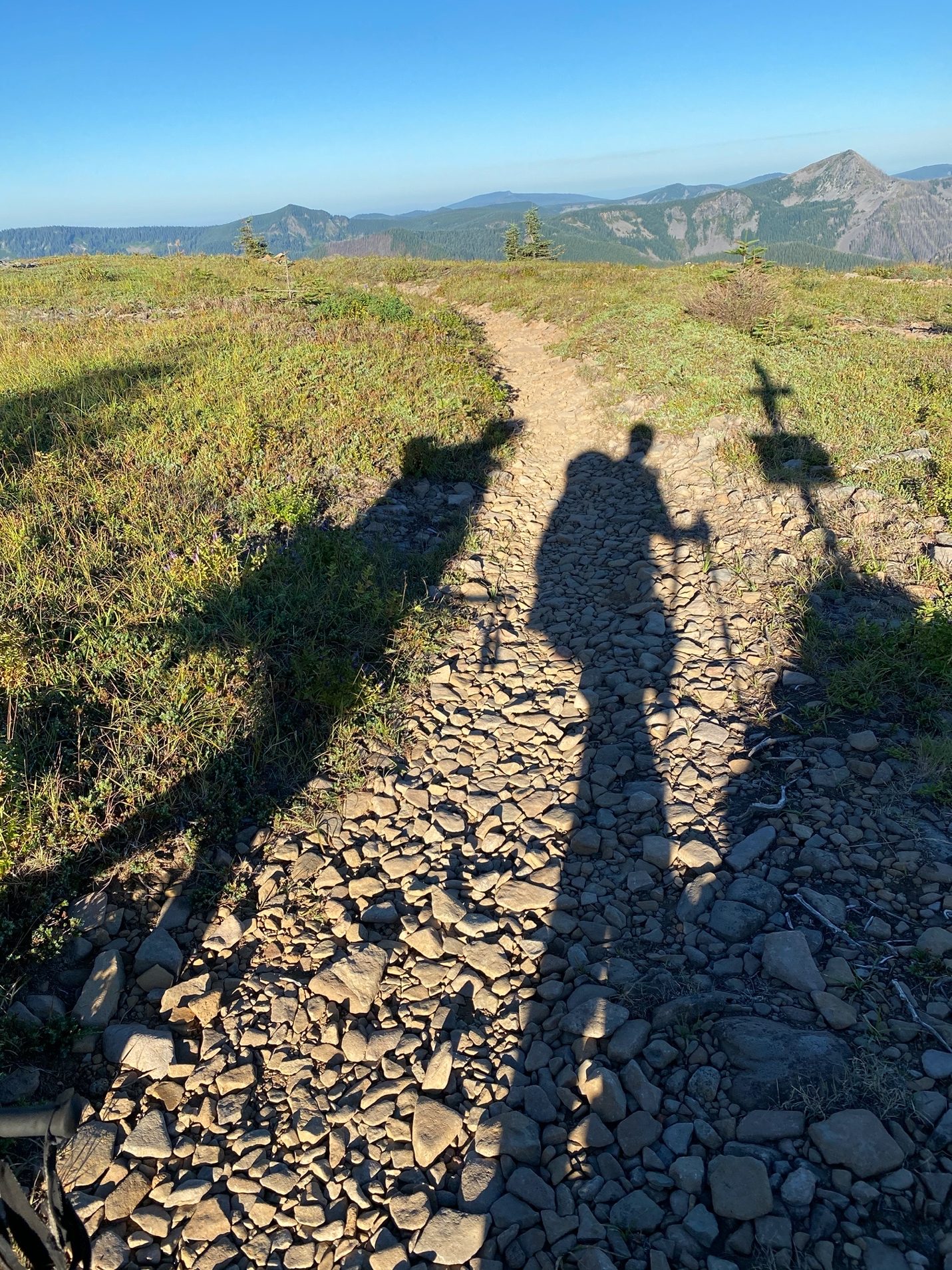
Porcupine Mountain – Soda Mountain Wilderness
We were shooting to camp at what Guthook called a “Faucet and Tentsite” at Mile 1728.1. We got there just as it was getting dark, but there were already people camped there. We resupplied our water and decided to keep hiking. We came to a dirt road 0.3 miles farther down the trail with a gravel turnaround. We were a little worried that someone might pull into the turnaround without looking during the night, but after nearly 16 hours of hiking, we were done. We had covered 36.7 miles, 4.1 miles more than the 32.6 (32.557) miles that we needed to average to cross Oregon in 14 days.
We quickly set up camp and cooked dinner. We had cell reception, so I phoned my wife, Melanie, and gave her an update on the day and the day before. She asked how it was. I told her, “Is is hard. It is very hard.”
I laid out my bivy, inserted my three-quarter length sleeping pad and 50 degree quilt into it, and crawled in. It took me a while to fall asleep. I lay there looking up into the star-filled sky. It had been a good day.
Day 2 – August 12th – 34.9 miles – 5,100 ft.

The next morning, we got up around 4 AM. We decided to swap the gear in our packs so we were carrying our own stuff. Katrina’s gear wouldn’t fit in my pack, so I carried her Zpacks Duplex tent, her Feathered Friends 20 degree sleeping bag, and her stove, which we were sharing. None of this weighed much; it was just bulky. I was disappointed that the gear wouldn’t fit into Melanie’s pack because that meant that Katrina would not be able to use my pack (Melanie’s pack) for the remainder of her hike. She would have to carry Atomic Bomb again when we reached Washington State.
Reorganizing the gear took some time, so we didn’t get started until around 5 AM. We stopped around 6:30 at a spring and, in what would turn out to be a rare morning luxury, Katrina broke out her stove. Katrina cooked some chia seed pudding for herself, and I heated up some of my oatmeal. Katrina couldn’t eat oatmeal anymore. I understood; I couldn’t eat oatmeal for years after my AT hike.
As we continued on, Katrina started feeling sick. She was nauseous and light headed, and she was having to stop very frequently to pee. I was worried about hyponatremia. We had drunk a lot of water the day before, and Katrina hadn’t used any electrolyte replacement. I gave her some of my salt tablets.
When we crossed Route 68 at around 9 AM, Katrina was feeling very poorly. We discussed whether we needed to get her to a hospital. She lay down. Fortunately, after 10 minutes or so, she started to feel better. We continued on, taking it slow and easy. The symptoms returned off and on, but they were not as bad.
We stopped for an early lunch at round 11 AM at Little Hyatt Reservoir, and we took a couple of shorter breaks in the early afternoon. We were both feeling pretty fatigued. Neither of us does well in the heat, and we were noticing that the afternoons were the toughest for us.
Around 4 PM we reached Howard Prairie Canal, a concrete water duct. We were exhausted. Katrina took offer her shoes and soaked her feet. We ate some food. Thirty minutes later, we were back on the trail, feeling better, powering up Mt. Baldy. We still had 12 miles to go.
After clearing Mt. Baldy, we descended about 700 ft. The rest of the day was pretty flat. We had been hiking generally north all day. It felt good to be going in that direction, knowing that we were headed to cooler temperatures. The forest was already changing. The trees were taller, and there was more shade.

It got dark around 8:45. We continued hiking to South Brown Mountain Shelter, arriving there around 9:30. Fortunately, we had the place to ourselves. Comments on Guthook reported lots of mice in the shelter (which was a log cabin), so we set up camp outside. While I was laying out my bivy, I was startled to see a deer standing about 10 ft. away at the edge of the woods. She wasn’t at all bothered by me. I didn’t want her nosing around my stuff in the night, so I yelled at her and chased her off.
I wasn’t that worried about deer. My main concern was that they might chew on Katrina’s pack to get at the salt. I was worried about bears, though. As I did every night, I put my food in my Ursack and tied it to the base of a tree not far away. Katrina, on the other hand, slept with her food in her tent, as she had since the beginning of her hike.
As usual, Katrina had pitched her tent, cooked both of our dinners, eaten hers, checked out the trail ahead for the next day, and was fast asleep, long before I managed to crawl into my bivy.
We had added 2.3 miles to our goal surplus, which was now up to 6.5 miles.
Day 3 – August 13th – 35.4 miles – 4,900 ft.

We were back on the trail at 4:52 AM. The first part of the day was spent traversing around Brown Mountain and its lava fields. Fortunately, the trail was exceptionally well built. There were a few places where the footing wasn’t perfect, but overall, the trail was a superhighway by eastern standards.

As we worked our way around to the northwest side of Brown Mountain, Mount McLaughlin, a dormant volcano, came into view.

Mount McLoughlin – Sky Lakes Wilderness
On Day 3, we ran into some more thru-hikers. We were hiking along, and one hiker came up fast behind us and flew by. A few minutes later, another hiker did the same thing. And a few minutes after that, a third came along and passed us, albeit, not as fast. Katrina told me that this had been a common occurrence on her hike. She said she was not a fast hiker, and that other hikers would often pass her. She said they often took more breaks than she did, however, and that she would pass them later on. Sure enough, we passed the three of them taking a smoke break a little while later. Later, they passed us again. And then we passed them again. We saw them one more time at the end of the day when we were cooking our dinner.
For some reason that I can’t remember, we had decided to try cooking our dinner before getting camp for the night. There was a campsite down a side trail from where we cooked our dinner, but it was farther off trail than we wanted to go. The other hikers went down the side trail to camp for the night.
As the sun was setting, we packed up and hiked on. We were on our way to Lucifer Peak and Devil’s Peak. I should have paid more attention to where we were going. I would come be a little afraid of sunsets.

Sunset – August 13th
The trail took us up on a ridge. After dark, Katrina found a nice spot on the ridge that would work for a campsite. It wasn’t marked as a campsite on Guthook, but it was a good spot. While we were trying to decide if we should stay there, I read a comment in Guthook for the Seven Lake Trail Junction, that was a little more than a mile ahead. The junction wasn’t listed as a tent site, but the comment read: “Great tentsites at the top of Devil’s Peak. Take the side trail. Hail satan.”
The hook was set. Human nature is such that if there is the prospect of something better than what we have right now, we naturally want it. It doesn’t matter if what we have right now is perfectly fine, or if we can even take advantage of what makes the other thing better; if there’s something else that’s better, we want it. In this case, the thing that made the other campsite better was undoubtably the views from it. But we would be arriving after dark and leaving before first light, so we would not be seeing any views from the campsite. That didn’t matter. It had “great tentsites,” no I naturally wanted it.
I didn’t suggest that we press on, but I’m sure the tone of my voice made it clear that was what I wanted to do. Katrina, who had more experience with these things, was skeptical, but I suspect she sensed my preference. We decided to keep going.
The hiking got bad pretty quickly. The trail around Lucifer Peak is an ascending traverse cut into a steep side-slope of loose scree that fell off into a dark void to our right. It felt like one wrong step could send us careening off into the abyss.
Another thing that we hadn’t figured out yet, was that Katrina’s brain shut down when the sun went down. As soon as it got dark, her cadence would drop to death-march pace, and she would sink into a cognitive and emotional low.
This might be a good place to mention that Katrina’s trail name was C4. I had learned this a month or so before the hike and had shared it on a family chat. My sister had asked, “What does c4 mean.” My dad, Katrina’s grandfather, answered, “Very stable explosive except when triggered.”
Well, C4 had been triggered. The combination of the bad trail conditions, the knowledge that we had left a perfectly good campsite behind, the accumulated fatigue of the three big mileage days, the emotional low that came with the darkness, and the bad spirits surrounding Lucifer and Devil’s Peaks proved to be too much. A stream of profanity started flowing in front of me. I just followed along in silence.
Then things went from bad to worse.
We finally made it around Lucifer Peak and came to a side trail. It was the Snow Lakes Trail junction, the one that had the comment in Guthook about the side trail to the Devil’s Peak tent sites. We assumed this was the side trail that the comment spoke about, and we started down it. It didn’t feel right though. Katrina started talking about how “angry” she was going to be if this was the wrong trail. It turned out that it was the wrong trail. We turned around. Katrina was not happy.
My GPS track shows that the detour cost us 11 minutes and about 0.5 miles. It felt like two or three times that.
We kept trudging along. After another 17 minutes and 0.7 miles, and another nasty traverse across more loose scree, we came to another side trail. After the debacle at the last side trail, I didn’t want Katrina to have to go any farther than necessary, so I told her to wait at the junction while I checked it out. I hiked up the trail. The trail got steeper and worse, the higher I went. I was pretty sure it was the correct trail, but I couldn’t imagine Katrina hiking up this steep, rough trail. I retreated back to the junction and told her it was probably the right trail but that we should keep going.
From there, the trail descended off Devil’s Peak. Seven minutes later, Katrina found a place beside the trail where she could pitch her tent, and we stopped for the night. It was 10:28 PM. We had been hiking for 17 hours and 36 minutes. Katina pitched her tent, climbed in, and informed me that she was going to sleep in.
We had had to fight hard for it, but we had added 2.8 miles to our surplus. We were now 9.3 miles ahead of our goal pace.
Day 4 – August 14th – 27.5 miles – 2,800 ft.

“Sleeping in” turned out to be rising at 5:00 AM. We were back on trail at 5:32. We stopped at the first water stop for about 25 minutes, and had some breakfast.
Today, we would pick up our first resupply at the Mazama Village Store in Crater Lake National Park. It was 22.2 miles from where we camped to the road that led to the store. The store was about a mile from the trail.
In addition to resupplying, I needed to get a backcountry permit to be able to stay overnight in the park. Katrina’s PCT permit covered her, so she didn’t need a permit. To get the permit, I needed to get to the park’s Steel Visitor Center, which was 4 miles, one-way, from the Mazama Village Store. I was hoping to be able to hitch a ride, but with the pandemic, I knew there was a good chance I would need to hike 8 extra miles to get the permit.
Knowing all this, Katrina suggested that I hike ahead. That seemed like a good idea. I told her to take her time, and that I would try to pick up our resupply packages and make it back to the trail so she didn’t have to do the extra 2 miles to the store. Katrina gave me her license so I could pick up her package, and we made sure we could send messages between our InReach devices. Then, I hiked ahead.
I hiked as quickly as I could. It helped that my pack was light. I crossed, the first of many burned out sections of forest that we would encounter. It was hot hiking under the sun with no break.
I made it to the store around 1:30. I went in and bought some Gatorade. I asked the checkout clerk what was the best way to get to the Steel Visitor Center. He answered, “Walk the road.”
So that’s what I did. There wasn’t any place where I could leave my pack safely, so I carried it. I tried hitchhiking, but there were not many places where a car could pull over safely. I ended up having to hike the 8 miles.
The good thing about me having to hike these miles is it gave Katrina a chance to take it easy. She was able to take some breaks along the way and recover from the day before.

Katrina Giving Her Feet a Break
We timed it pretty well. As I was nearing the store again, I received messages from Katrina saying that she was nearing the road crossing. I suggested that she wait for me there, but she decided to come to the store. Katrina arrived shortly after I did, around 5 PM.
It turned out to be a good thing Katrina came to the store. She had sent two resupply packages to the store by mistake, and I would have had a hard time sorting out what to do about that without her help. We binged on ice cream and other treats while we sorted out our resupply packages.
In a way, it was fortuitous that Katrina had sent two resupply packages to the Mazama Village Store. She had underestimated how much food she was going to need to fuel herself through the additional miles we were doing now. Prior to reaching Oregon, Katrina had been averaging an impressive 25 miles per day, but now we were hiking about 40% more miles per day. She needed a lot more food. She cherry-picked the most desirable items from her two resupply boxes, and then gave the rest away to a very grateful thru-hiker.
We left the store about an hour later, around 6 PM, with much heavier packs. We hiked back to the road crossing and finished out the day hiking 5.3 miles farther, over mostly flat trail. Along the way, we ate a sausage and cheese ball that Katrina had bought at the store. It tasted so good. We were both running significant calorie deficits, and high-calorie food tasted heavenly.
We stopped a little before 8:30—importantly, before it got dark. We had only covered 27.5 PCT miles for the day. That subtracted 5.1 miles from our surplus, bringing it down to 4.3 miles. We knew that it was going to be hard to cover 32.6 miles on days that we resupplied, and that, as a result, we needed to bank some miles on the other days. We had eaten into our surplus more than we would have liked, but we still had a surplus.
Day 5 – August 15th – 34.3 miles – 4,200 ft.

The next morning, we started early. We were hoping to beat the heat. Katrina, as usual, was ready before I was, so she started without me. I got going at 4:23 AM.
About a mile down the trail, I crossed Bybee Creek. There was a big arrow high up on a tree pointing to the right, and the trail turned right. I followed along. As Katrina had taught me, I checked Guthook after a minute or so. Guthook showed that I wasn’t on the trail anymore. I turned around and walked back to where I had diverged from the trail. It was right where the arrow was on the tree. I didn’t see any trail heading in the direction that Guthook said the trail went, so I turned around and went back up the way I had come.
I hadn’t gone far when I saw a headlamp coming back toward me. It was Katrina. She said we had gotten off the trail. I told her I had gone back and checked out the junction and couldn’t find the trail. I told her I thought the trail had been rerouted and that Guthook didn’t have the reroute. I almost had her convinced of this, but Guthook had never misled her. Katrina said we should go back to the where we had diverged from the trail. We did, and sure enough, the trail went where Guthook said it did. I just couldn’t see it by the light of my headlamp.
We continued along. As the sun rose, we entered another large, burned out area of forest. One of the drawbacks of doing the Oregon Challenge or hiking in the PCT in the purist style is the official PCT does not go to the rim of Crater Lake. It traverses around it, through a lot of burned-out forest, never coming withing view of the lake. For this reason, almost all PCT hikers take an alternate route that takes them along the rim of the crater. I had visited Crater Lake for the first time a few weeks earlier, but Katrina had never seen it. She’ll have to go back to see it someday.

Katrina Hiking the Official PCT in Crater Lake National Park
We saw a couple of bears about 100 yards off the trail in the burned out section. This was good to see. The forest and wildlife were starting to come back.
We reached Crater Lake Highway North at around 10:30 and resupplied water from a water cache that was located there. From there, we turned north and began a hot, dry section.
I was dragging. The extra weight from the resupply and the 8 mile side trip to the Steel Visitor Center the day before had taken a toll. Also, I had developed blisters, and my feet were quite sore. I had attempted to avoid blisters by pre-taping my feet at the start of the hike with Rock Tape, but it hadn’t worked. If anything, it made them worse.
Katrina, on the other hand, seemed to be doing very well. Apparently, the 29.5 miles she had hiked the day before was now a “recovery day” for her.
We stopped for lunch at around 1:30. While we were stopped, a guy came hiking up the trail, traveling southbound, wearing only hiking shoes and a hat. He covered up with his hat as he went past and said hello. After he went past, Katrina and I looked at one another thinking, “Did that just happen?”
After lunch, we continued north out of the park.

Crater Lake National Park – Northern Boundary
Shortly thereafter, we reached East Diamond Lake Highway. There was another water cache a short while after the road crossing, and several thru-hikers were stopped there. One, a woman named Wildcat (trail name), said the naked guy had approached her without covering up and invited her do some naked hiking with him. She passed.
Here we also met a very nice thru-hiker from Austria, name Lowlander, who had previously hiked the AT. It was a lot of fun for me to hear him talk about some of the New Hampshire sections of the AT. He remembered the brutal climb up South Kinsman. My own memory of that climb from 39 years earlier, was still vivid.
Katrina was feeling pretty tired and wanted to try to take a nap. She went off into the woods a bit and tried to sleep while I chatted it up with the other hikers. Katrina couldn’t sleep. She got up and got ready. She was ready before I was, so she hiked ahead. I got packed up and started a few minutes after her.
From the water drop, the trail climbs up the shoulder of Mt. Thielsen. As I was climbing, a thunder storm rolled in. It started raining a bit, and I took out my rain shell for the first time. As soon as I got it out, however, the rain stopped. I was expecting a big, eastern-style thunder storm with an accompanying deluge, but this was barely more than a sprinkle.
Katrina had stopped to wait for me, and I caught up to her shortly after it stopped raining. We continued hiking around Mt. Thielsen. The clouds periodically dropped some sprinkles on us, but it never really rained. We stopped at beautiful Thielsen Creek to cleanup, cook our dinner, and resupply our water. It was the coldest, clearest water we had seen in a long time. Our stop there was the highlight of the day.

Thielsen Creek and Mount Thielsen
We left Thielsen Creek at around 7:30 PM and hiked another 4.4 miles to just before the Oregon High Point. We arrived there at 8:54 PM. Our mileage for the day was 34.2 miles, which added 1.7 miles to our surplus, bringing it to 6.0 miles.
Day 6 – August 16th – 34.3 miles – 4,700 ft.

The next morning, August 16th, we got started at 4:20 AM. A few minutes after starting, we reached the highest point on the PCT in Oregon and Washington, an elevation of 7,568 ft.

Oregon / Washington High Point
In the dark, and later in the early morning light, we passed tents in which hikers were still sleeping.
Later that morning, Lowlander, the hiker from Austria we had met the day before, came cruising up behind us. Lowlander was a stocky man, but he was fast! He told us of the beautiful view he had from a lookout where he had camped the night before. A view, we had walked past in the dark.
Later, another hiker came speeding behind us. He told us his trail name was Nap and that he was from Finland. He said that he and his wife had hiked from Mexico together, but just before Oregon, his wife had started suffering from an overuse injury. She had gotten off the trail and was staying in a hotel in Portland, trying to recover. She hoped to rejoin him for the Washington section. Nap was trying to cross the state quickly, so he could rejoin her as soon as possible. He had started trying to do the Oregon Challenge, but one of his resupplies had been far off the trail and had taken too long. Now, he was just trying cross as quickly as he could. After visiting with us for a few minutes, he sped off, hiking with a distinctive speed-walker stride. His pace was probably 50% faster than ours. I was super impressed.
We noticed that the forest was changing. Since leaving Crater Lake National Park, the trees had gotten taller and provided better cover. Katrina commented on how the PCT kept changing as she hiked north, and how nice it was that there was always something new to experience.

Mount Thielsen Wilderness
As it was getting dark on Day 6, we passed Lowlander, who was setting up camp. We visited with him for a few minutes and then hiked on. It got dark soon thereafter, but we pressed on. We found a nice campsite at 8:54 PM. We had covered 34.3 miles for the day, adding 1.7 miles to our surplus, which was now 7.8 miles.
Day 7 – August 17th – 30.5 miles – 4,000 ft.

On Day 7 (Monday, August 17th), we started hiking at 4:50 AM. As the sun was coming up, we came to a small pond.

Sunrise – Diamond Peak Wilderness
In the mud on the bank of the pond, there were mountain lion tracks. We had seen mountain lion tracks a few times on our hike, but, thankfully, we never saw a mountain lion.

At some point during the morning, Nap came speeding up behind us again. We must have past his campsite at some point in the early morning. He had probably hiked about as far as we had the day before, and he had a surprised look on his face when he saw us. We asked if he had heard anything from his wife. He said her injury wasn’t getting better, and it was looking doubtful that she would be able to rejoin him. He said she would decide soon if she would head back to Finland, and he expected that she would. He was clearly down about it. We visited for a couple minutes, and then he hiked on.
We ran into Nap again a few hours later. He had stopped for lunch at Lower Rosary Lake, a small, crystal-clear lake, with Pulpit Rock rising behind it. He was just getting ready to leave when we arrived. He told us his wife had decided to go home and that he was trying to decide what he should do. He was struggling with the decision. He said it was hard to hike alone after hiking so far with his wife. He expressed frustration with the heavily-forested section of the trail we were hiking through and said that there was plenty of forest to hike through back home in Finland. He was missing the expansive vistas of the desert and other sections of the trail to the south. We expressed condolences and encouraged him to continue.
After Nap left, Katrina and I had lunch and went for a swim. The water was frigid, but it felt fantastic to wash off a week’s worth of trail grime.

Lower Rosary Lake and Pulpit Rock
Unfortunately, the benefits of the swim didn’t last long. We were dirty again within a few hours.
That afternoon, we reached the halfway point across Oregon. It felt good to be halfway to our goal and to be on schedule.
By this time, we had settled into a routine and were getting more used to the long days and miles. We would rise early, get more than half the day’s miles done before lunch, slog through the heat of the day, and then power hike the last 4 hours of the day to reach our mileage goal. We were taking a lot fewer breaks, but it was still a challenge to hit our mileage goal each day. There were no easy days. We rarely, if ever, passed the 32.6 mile “minimum” before 7:30 PM.
Unlike myself, Katrina has a sensible attitude toward physical challenges. She feels little temptation to tackle big challenges that have no purpose other than the challenge itself. In this case, however, the Oregon Challenge was a means to the end of getting back on her schedule and reaching Canada before the snow started falling. With this motivation, she had proven to be a very capable, tough and determined competitor. We were starting to believe that, barring some unforeseen obstacle, we had a good chance of hiking across the state in two weeks.
Later in the afternoon, however, we started hearing a lot of planes flying overhead. Katrina said she had been told to pay attention to planes because their presence usually meant there was a fire in the area.
We reached Charlton Lake at around 7 PM and resupplied our water. As we were hiking away from the lake, Katrina was a bit ahead of me. I noticed that she had stopped and was talking to someone off to the left. When I caught up, there was a group of about 8 hikers there and a couple that was treating the hikers to some trail magic. Nap was there. The hikers told us there was a fire a few miles ahead on the trail.
Then, one of the hikers exclaimed, “Katrina?!” It was Forest Gump, the hiker who Katrina had met in the Sierras, and whose name Katrina had seen in the trail register at the state line. Forest was overflowing with the nervous energy of someone who just encountered something dangerous. He told us he had hiked up to where the fire was burning, and he showed us a video he had taken from the fire. He had gotten within a few yards of the fire and had seen firefighters fighting the fire.
Forest then told Katrina he “had a confession to make.” He said he had first seen Katrina in the desert. He said he was in the front of a group of hikers when Katrina had come up behind them. Someone else in the group had asked Katrina when she had started her hike. When she answered, May 9th, the day after Forest started his hike, Forest said he took off ahead because he didn’t want her to pass him. Katrina and I got a big kick out of that. It was totally consistent with the story Katrina had shared with me at the state line about her encounter with Forest in the Sierras, where Forest had sounded concern about when she had started until Katrina said she had not done the side-trip to Mt. Whitney.
Katrina then mercilessly informed Forest that she had taken 9 zero days after the Sierras.
The group was trying to decide what to do. Some were considering a long road walk that would go around the fire. Others were talking about trying to bushwhack around the fire. Katrina and I were wondering if this was going to be the end of our Oregon Challenge.
Katrina phoned Nico and asked him to investigate. While Nico was looking into it, we all hiked the short distance back to Charlton Lake and set up camp there for the night. Katrina and I figured that we would try to hike around the fire in the morning, and since we would be leaving early, we set up camp away from the others.
Nico called back and, true to form, he had found the info we needed. He told Katrina the fire was called the Lily Fire. It was burning near the PCT, but the PCT was still open. PCT hikers were just cautioned to be aware of the fire. Katrina went over to the other hikers and passed along the information Nico had provided.
We finished setting up camp and went to bed. Since we had stopped short of our goal for the day, we ended up only covering 30.5 miles for the day. This subtracted 2.1 miles off our surplus, and brought it down to 5.7 miles.
Day 8 – August 18th – 30.3 miles – 2,900 ft.

In the morning, we packed up as quietly as we could and started hiking at 4:37 AM. When we were mile or two from where we had camped, I realized that I didn’t have my prescription sunglasses. I had left them where we had camped. They were very expensive, but there was no going back for them.
A little while later, we started to see an orange light ahead in the dark. Katrina wondered if it was the sun or the fire. It was the fire. The trail took us closer and closer to it. The fire hadn’t crossed the trail, but it was burning within about 100 ft. of it. Fortunately, the wind was blowing away from the trail, and we were able to hike past it without leaving the trail.
Lily Fire – Waldo Lake Wilderness
A little over 24 hours after we hiked past the Lily Fire, officials of the Deschutes and Willamette National Forest closed this section of the PCT. If Katrina and I had not been attempting to complete the Oregon Challenge, we would have arrived here after the trail had been closed, and Katrina would not have been able to complete her goal of hiking the entire length of the official PCT. Once again, the Red Sea had parted and let her through.
Later that morning, Nap past us. And then, a while later, Forest Gump and a woman whose trail name was The Dude, hiked past us. Forest was all business and paused only briefly as he went by. Like many thru-hikers, Forest and The Dude hiked much faster than we did. The night before, The Dude had told us she generally hiked 27 miles per day. Forest knew that we were attempting the Oregon Challenge, so he knew that he would need to do over 32+ miles per day to keep up with us. We wondered if that was creating some stress in their relationship.
Just before 4 PM, we reached the side trail to Elk Lake Resort, our second resupply location. It was about 1.2 miles down the side trail to the resort. We arrived there around 4:30. We picked up our resupply packages, bought a few treats, and paid for a shower.
Forest and The Dude had stopped at the resort to get a meal at the resort’s restaurant. They packed up soon after we arrived and headed back to the trail.
The shower was amazing. We had been able to swim the day before, but I was filthy. I couldn’t get the dirt off my feet; it was too deeply embedded. I washed my clothes as best I could in the shower. I took longer than I was supposed to, and there was a woman and child knocking at the door before I was done. I tried to clean up the mess I had created with some paper towels, but it was hopeless. I only had one change of clothes, so I wore my wet clothes out of the shower.
After our showers, Katrina and I ate dinner on the patio at the resort’s restaurant. Then, we shouldered our packs and started hiking back to the PCT. We had been stopped for about 90 minutes.
On the way back to the PCT, we missed a turn and hiked the wrong way for a bit. We noticed our error pretty quickly and turned around. The mistake only cost us about 15 minutes.
We hiked into the dark that night. We thought the stop might give us some extra energy, but the setting of the sun brought with it the usual mental low. We were shooting for a campsite at Mile 1957.2, but we found a place where we could camp at Mile 1955.6. We stopped there at around 9:15 PM. We had covered 30.3 PCT miles for the day. This deducted 2.3 miles from our surplus, and brought it down to 3.4 miles. It wasn’t much of a buffer, but we were still slightly ahead of schedule, despite the resupply and the delay caused by the fire.
Day 9 – August 19th – 33.1 miles – 5,000 ft.

We were back on trail at 4:40 AM. We climbed up over Koosah Mountain in the dark. The campsite we had been shooting for the night before was near the summit. The campsite was very nice, and it appeared to have a very nice view. It was still dark, however, so we didn’t get to enjoy it.
We hiked down the north side of Koosah Mountain and past Sisters Mirror Lake at around 7 AM. It was very cold by the lake, and there were some other hikers camped there. We suspected that Forest Gump and The Dude were among them.
As the sun was coming up, we hiked through one of the most beautiful valleys we had seen in Oregon. Colorful wild flowers carpeted the valley floor, and the first of the Three Sisters, South Sister, towered above it. Smoke from a campfire wafted across the valley. It was one of many beautiful views we would see on this day.

South Sister – Three Sisters Wilderness
As we hiked through this valley, I thought of Nap and how happy he would be so see a big vista like this again.
We exited the valley, passing a massive wall of lava at the base of South Sister and continued on north. As we past to the west of South Sister, we came into a lush area with a view of Middle Sister.

Middle Sister – Three Sisters Wilderness
Not long after that, Nap caught up with to us again. He told us had had decided to finish the PCT. I was very happy to hear this. It was very sad that he and his wife would not get to complete the trail together, but after going so far, I was very happy that Nap would get to complete it.
Nap was planning to stop in the town of Sisters at the end of the day to resupply. He hiked on ahead. We wouldn’t see him again in Oregon.
A while later, Forest Gump passed us. Again, he was all business. Katrina got a kick out of how much angst she was apparently causing him, albeit totally unintentionally. A while after Forest passed us, The Dude went by.
Around noon, we passed through the beautiful Obsidian Natural Area. The Dude and Forest Gump had stopped there for lunch, but at different spots.

Obsidian Falls – Three Sisters Wilderness
We stopped for lunch just outside the area. While we were stopped, Forest and The Dude went by again. Like Nap, they were heading into the Sisters to resupply. They hiked on. We would not see them again in Oregon either.
After lunch, we left the lush vegetation of the Obsidian Natural Area behind, and moved into an exposed area of lava flows.

Collier Cone Lava Flow – Three Sisters Wilderness
The sun was intense in this area. By mistake, I had left my baseball cap in my computer bag, that my daughter, Brianna, had picked up from me during my layover in Seattle. As a result, I only had my bandana for sun protection during the hike. Since the sun was often behind us as we hiked north, I often wore my bandana so it covered my ears and the back of my neck.

And no, despite what it says on my shirt, I have never run the Western States 100. The shirt was a gift from my brother John, who ran the race in 2010. I only supported him. The shirt is a GoLite shirt that weighs nothing. It was the perfect shirt for this hike.
We spent the last three hours of the day crossing a massive lava field south of Mount Washington. The trail was a feat of engineering, but it was tough going. The footing was tricky and required a lot of concentration. The lava rocks were very sharp and rough. I was worried that I would blow out the sides of my Altra Lone Peaks, so I was very careful where I put my feet.
We were rewarded for our efforts with beautiful views of North Sister and Middle Sister, which were now behind us.

North Sister and Middle Sister from Mount Washington Wilderness
The lava fields, themselves, were very beautiful, but we were not appreciating them. We were very tired and very unhappy hiking through this section.

Lava Fields – Mount Washington Wilderness
We camped at the first available tent site, which we reached at around 8:20. The campsite was in a protected hollow, but it was quite windy, nonetheless. We had covered 33.1 miles for the day, adding 0.5 miles to our surplus, which was now 4.0 miles.
Day 10 – August 20th – 32.6 miles – 4,700 ft.

After our rough finish on Day 9, we decided to sleep in on Day 10. We got started at around 5:40 AM. We didn’t know how much farther we would have to hike through the lava fields, and we were dreading the start of the day. We were pleasantly surprised, however, to find that our campsite had been near the end of the lava fields. We were soon hiking through glorious, green vegetation, with Mount Washington, rising above it.

Mount Washington – Mount Washington Wilderness
At the pace we were going, we were passing 100 mile milestones every 3 days or so, and around 11 AM, Katrina reached the 2,000 mile milestone of her hike.
We hiked past Three Fingered Jack, but we had no idea what it was called at the time. I was thinking it was Mt. Jefferson. Guthook is great at telling you where the tent sites and water sources are, but its maps don’t give you much detail on the mountains you are hiking past.

Three Fingered Jack – Mount Jefferson Wilderness
One thing that was somewhat depressing on our hike was that we were confronted, on almost a daily basis, with the devastation of forest fires. According to the Insurance Information Institute, 4.2 million acres of forest were burned in Oregon between 2011 and 2019. We were fortunate to compete our hike before the worst of the 2020 fires, which burned an additional 1.2 million acres. In total, 5.4 million acres of Oregon’s forest has burned in the past 10 years. That’s 18% of Oregon’s 30 million acres of forest.
On this day, as on most days, we saw large tracts of land that had been burned. We also saw a fire burning off in the distance.

Wasco Lake – Mount Jefferson Wilderness
Toward the end of the day, we were treated to a stunning view of Mount Jefferson.

Mount Jefferson – Mount Jefferson Wilderness
We stopped for the day at around 8:30 PM, at Hunts Creek Trail Junction. There was another tent there, so we set up camp as quietly as we could. We had covered 32.6 miles for the day, exactly our daily goal. That maintained our surplus to 4.0 miles.
Day 11 – August 21st – 34.2 miles – 5,000 ft.

The next morning, we started hiking at 4:44 AM. In the dark, we started hiking back the way we had come, but we quickly realized we were going in the wrong direction and turned around.
We spent the morning hiking around Mount Jefferson. Some bad weather rolled in, and it started raining. This would be the only day that Katrina would experience steady rain on her entire PCT hike. She had been in a few brief thunderstorms that spit rain and frozen precipitation, but this was the only day where it rained for a good percentage of the day.
At a little after 10 AM, we came to Russell Creek. It looks small in the picture, but it about 15 feet across and was swollen and raging. We couldn’t see the bottom, so we had to probe with our trekking poles to see how deep it was. The water was thigh deep in places, but we managed to get across.

Russell Creek – Mount Jefferson Wilderness
We spent the rest of the morning ascending Park Butte, to around 6,800 ft. We crested the ridge just after noon and started down the other side. We had to cross a few small snow fields on the way down.
In the afternoon, we started dreaming about the Lake Olallie Resort General Store. The store was not one of our scheduled resupply points because the store does not accept resupply packages. The store is close to the trail, however, and we had decided to stop there and supplement our food supplies. Body fat had been melting off our bodies at an alarming rate since the Oregon State Line, and we both had ravenous appetites.
Katrina is an excellent cook, and she had dehydrated most of her food herself before the start of her hike. I’m pretty sure she ate better than anyone else on the PCT in 2020. But while her food was perfect for a long distance hike, what we were doing now was more like a race than a hike. We were doing over 50k every day, with heavy packs. For this type of effort, the snack (junk) foods that I had brought were great supplements. Katrina really liked my Clif Bloks and Oreos and Cheez-Its and chips. The Lake Olallie Resort General Store gave her a chance to stock up.
We got to the store a little before 5 PM. The store is very small and only accepts cash, but it was amazingly well stocked for hikers. I treated myself to a Coke and restocked my snack foods. I had read that Fritos have a higher calorie density than almost any other food except for pure fat, so I picked up a bag. Katrina bought a bunch of snack foods too, including a package of Oreos. She ate about half of the package while we were at the store, and finished it off before the end of the day.
About 40 minutes after arriving at the store, we headed back to the trail. We covered another 9.4 miles and then stopped for the night at 8:30 PM at Trooper Spring. It looked like it might rain during the night, so I set up my poncho tarp over my bivy. We have covered 34.4 miles for the day, which added 1.6 miles to our surplus, bringing it to 5.7 miles.
Day 12 – August 22nd – 36.5 miles – 4,400 ft.

It didn’t rain during the night. I would have liked to have seen how my bivy and poncho tarp held up to rain, but I was grateful to get a good night’s sleep.
As usual, Katrina was ready to go before I was, so she went on ahead. I got started at 5:25 AM.
We spent most of the day hiking through Redwood forests. Some of the trees were very large.

Near Timothy Lake
We hiked past Timothy Lake in the early afternoon. It was the weekend, and there were a lot of people camping and picnicking and hiking around the lake. It looked like a fun place.
In the early evening, we got our first views of Mount Hood.

First Views of Mount Hood – Mount Hood National Forest
We hiked until 9:30 PM, around an hour after dark. We camped at the Barlow Road and Trailhead, right next to the trailhead parking lot. There were some people hanging out in the parking lot, but we got to enjoy the luxuries of picnic tables and a porta-potty. We had hiked 36.5 miles, the most since our first day. This added 3.9 miles to our surplus, and brought it up to 9.6 miles, a nice cushion, with only 2 days to go.
Day 13 – August 23nd – 30.3 miles – 6,400 ft.

After arriving late in camp the night before, and given that we had ample surplus, we decided to sleep in. We didn’t get going until 5:53 AM. It was our latest start of the hike.
Today we would climb onto the slopes of Mount Hood and traverse around it. We were still in the valley, but the location of the trail signs on the trees was an indicator of how much snow this area gets. On Mount Hood, the snow depth reaches 13 ft., on average.

Mount Hood National Forest
Before long, we were climbing up at tree line.
 Mt. Hood – Mount Hood National Forest
We reached Timberline Lodge at around 8:20 AM, which was our last resupply location. We picked up our resupply packages at the ski lodge and went through them. We only had one more day to go, so we left quite a lot of our resupply goods in the hiker box.
After sorting through our resupply packages, we continued on traversing around Mount Hood. It was the weekend, and there were a lot of people out hiking. We had to use our face masks a lot, something we were not used to doing. The views were stunning, however. It was easy to see why there were so many people here.

Mount Hood – Mount Hood Wilderness
After a long descent, we stopped for lunch at Rushing Water Creek at around 1:30 PM. I rolled out my poncho tarp and dug all my best treat foods out of my pack. With only one day to go, there was no need to save the good stuff. Then I took a little nap.

Lunch Nap at Rushing Water Creek – Mount Hood Wilderness
After a 50 minute break, we were back on the trail. Mt. Hood was behind us now, but we continued to have great views of it throughout the rest of the day.
At around 7:30 PM we stopped for water at a spring. There were a lot of hikers camped near the spring. We were planning to camp at the next campsite, 2.6 miles farther north. Katrina resupplied her water and was ready to go before I was, so I suggested that she hike on ahead. I told her I would catch up.
A short while after leaving the spring, the trail went up a short, steep rock scramble. As I was climbing up it, I thought to myself that this was very uncharacteristic of the PCT. The trail crested a ridge and then petered out. I spent a few minutes hiking back and forth, looking for the trail. Guthook wasn’t very helpful here because the distances were small. “Beautiful,” I thought to myself, “I am on my own for a few minutes, and I managed to lose the trail.”
I hiked part way back down the rock scramble, but I couldn’t see where the trail went. I hiked back up the scramble; still no trail. Back down again. Finally, after getting all the way back down, I saw that the trail took a sharp turn through some bushes.
I was relieved to be back on the trail, but now I was way behind Katrina. I hiked as fast as I could and jogged the descents, but I didn’t catch up to Katrina until we were almost to our target campsite. It turned out to be a good thing that I caught up to her when I did, because when we got to the campsite, there were a couple of people cowboy camping there, already down for the night.
Katrina and I quietly discussed what to do. The next campsite was 4.5 miles farther, and it was already dark. After the night on Devil’s Peak, I was in favor of staying where we were. Katrina wanted to press on, though, so we did.
We could tell right away that this was going to be a tough 4.5 miles. It was dark, and we were both very tired. About 15 minutes after leaving the campsite, we came across an unmarked, faint side trail. I told Katrina to wait while I checked it out. A short way up the trail, there was a short spur trail that led to a small tent site on the top of a ridge with room for one tent and spot that I could squeeze my bivy into. I hiked back to Katrina and told her the good news. We were both very relieved.
We went back to the tent site together. I hiked a little farther up the side trail (which I would later learn led to Buck Peak) looking for a better site, but I didn’t find one. It was a bit windy and cold at the site I had found, but we were very grateful for it. It was a real gift. We set up camp quickly and went to bed.
With the late start, all the vertical, and the slightly longer lunch, we only covered 30.3 miles for the day, which deducted 2.3 miles from our surplus, bringing it down to 7.4 miles. That left us with 25.2 miles to go.
Day 14 – August 24th – 25.2 miles – 3,100 ft.

It was a cold, windy night up on the Buck Peak ridge, but my bivy, my 50 degree quilt, and my extra clothes kept me warm. We were back on the trail at 5:35 AM.
We had some parting views of Mt. Hood during the morning.

Final Views of Mt. Hood
It took us about an hour and 40 minutes to reach the rough dirt road and tentsites we thought we were going to have to hike to the night before. As we hiked past the road, we were both, very, very happy that we had not had to hike to it the night before.
At 7:47, we reached a ridge on Indian Mountain with beautiful panoramic views.
View to the West from Northwest Ridge of Indian Mountain
Around noon, we started the 4,000 ft. descent down to the Columbia River. Two people were hiking in to meet us: Katrina’s youngest sister (my daughter), Angela, and Katrina’s fiancée, Nico.
Angela reached us a little after 2:00 PM. A short while later, we made a final stop to resupply water, and Angela snapped this picture.

Final Water Resupply
Here in northern Oregon, the streams often had “strong flows,” like this one. Although it was a far cry from my eastern-based concept of a “strong flow,” it was much better than what we often encountered in southern Oregon. There, the flows were often described as a “trickle,” and good flows were rated in liters per minute, e.g., 1-2 liters per minute were common. At many sources, we had to scoop the water out of little pools with an empty tuna packet. I drank from sources I never would have touched back East. I learned to have a lot more confidence in my water filter on this hike.
A short while after resupplying our water, Katrina’s fiancée (and most awesome support crew ever), Nico, reached us.

Katrina’s Fiancée, Nico, Hikes in To Meet Us
From where we met Nico, it was about 3.5 miles to the Columbia River and the Bridge of the Gods. We reached the bridge at around 4:15 PM.
The views from the bridge were stunning.

Columbia River from Bridge of the Gods
There is no walkway on the bridge, and you can see through the bridge surface to the river far below. There was a strong wind. I tried not to look down.

Angela snapped this picture as Katrina stepped from Oregon into Washington at 4:19:28 PM.

The Oregon Challenge was complete. It had taken us 13 days, 11 hours, and 50 minutes to traverse the 455.8 miles of the Oregon section of the PCT.

Day 129 – September 14th – 2,653.1 miles – 455,000 ft.
Three weeks later, with the air filled with smoke from the fires that had broken out in Washington State, Katrina arrived at the Canadian border. She was accompanied by her sisters Angela and Brianna, and by Brianna’s dog, Ranger. “Nap” was also there. He needed a ride to Seattle when he finished his hike, and the girls had arranged to drive him there.

The Northern Terminus
Completing a thru-hike of the Pacific Crest Trail is an extremely difficult challenge in any year. In 2020, it was virtually impossible. On April 1st, the Director of Communications and Marketing for the PCTA, Scott Wilkinson, stated: “Because of the USFS statement, it’s now impossible to complete a thru-hike of the PCT, and remains that way indefinitely. The permits themselves have not been invalidated, but at the moment, they’re useless.”
The USFS statement that Mr. Wilkinson referenced stated that PCT permits require hikers to start at the permitted location and start date, comply with local regulations, and only allow travel on public lands that are open for travel. On April 1st, it was not possible to meet these requirements. The state of California had issued a stay-at-home order, and many of the public lands that the PCT traverses were closed.
But on May 8th, the day before Katrina’s permit specified that she needed to start her hike, California relaxed its stay-at-home order to allow travel for “outdoor recreation.” This enabled Katrina to start her hike without violating the terms of her permit. In addition, as she hiked north, parks that were closed when she started her hike, opened before she reached them.
In addition to the pandemic, massive wildfires broke out across the west in 2020. Katrina managed to stay ahead of the worst of the fires, but twice came very close to having her progress blocked by fire. In the first case, an advisory recommending that hikers refrain from using the section of the trail that was a few miles from the Bald Fire was lifted just before Katrina reached the section near the fire. In the second case, the PCT was closed a little over 24 hours after Katrina and I hiked past the Lily Fire, which was burning about 100 ft. from the trail when we passed.
Time and time again, obstacles melted away and let Katrina through. Hiking the PCT was supposed to be impossible in 2020, but Katrina had managed to do it. She had hiked the entire trail and met all the requirements of her permit. She had experienced the beauty and miracles of this earth that the PCT showcases, and her hike, itself, was beautiful and miraculous.
