
One day early last summer, my daughter Danielle asked me if I would hike the John Muir Trail with her. The John Muir Trail? I had hiked the Appalachian Trail when I was eighteen, but I knew almost nothing about the John Muir Trail. I did a little research and learned that it was 211 miles long, that you needed a permit to hike it, and that you generally had to apply for a permit months in advance. While it was conceivable that we could hike 211 miles within a two to three week vacation, it was too late to reserve a permit for that summer. When I informed Danielle of this, she was not deterred. She simply asked that we do the hike this year as her high school graduation present. I made no promises, but I secretly hoped we would be able to do it.
The months rolled by. Before I knew it, it was the third week of February. You can apply for a wilderness permit up to twenty-four weeks in advance, and I had read that the permits for Happy Isles, the northern terminus of the JMT, generally go as soon as they become available. That turned out to be true: there were no permits available from Happy Isles to campsites on the JMT for the end of June or the beginning of July. The twenty-four week window was opening up new permits in August, but that was too late because Danielle had to be at school in early August. One option would be to show up the day before our hike and try to get a first-come-first-serve permit, but we felt it was too risky to fly across the country without knowing for sure that we would be able to do the hike. It looked like we had missed our chance. Then I noticed that while there were no permits available from Happy Isles to campsites on the JMT, there were permits available from Happy Isles to Illilouette, which was a just a couple miles off the JMT. I quickly faxed off an application.
According to the information on the National Park Service web site, if you include your e-mail address on your wilderness permit application, the park service will notify you within one business day if your application is approved or denied. I included my e-mail address on the application, but I did not receive an e-mail. After several days, I assumed our application had been denied. Two weeks later, however, we received our permit reservation in the mail. Our third, and final choice for a start date, July 1st, had been approved. We could hike the John Muir Trail!
When I submitted our application, only Danielle and I had talked about doing the hike. My wife, Melanie, however, suggested that I request four permits in case any of our other children wanted to go. On her suggestion, I had specified a maximum of four people and a minimum of two on our application. We were approved for four. After we received the approval, Melanie decided that she would like to go. She knew the hike would be very difficult, but she felt it would be an experience she would not want to miss. We also invited our son, Michael, who had long wanted to do a hike like this. At first Michael did not think he would be able to take the time off of work, but when he realized the 4th of July holiday would save him two vacation days, he decided he could come.
Planning the Hike
Before we received our permit reservation, hiking the John Muir Trail was just an idea–something we might do. Now it was something we were going to do. We needed to start planning.
First, there was the gear to purchase. We had almost nothing. Melanie did almost all of the shopping. It was a lot of work, but it may have been the part of the trip that was most fun for her. The packages and shopping bags streamed in. Backpacks, pack covers, sleeping bags, sleeping pads, tents, headlamps, waterproof matches, clothes, boots, etc. I have no idea how much it all cost; I was afraid to ask.
The most difficult thing to plan was the travel. It didn’t help that, in addition to the hike, I was planning to run the Tahoe Rim Trail 100 with our daughter Brianna on July 20th. There were many constraints, and Melanie spent countless hours searching for an itinerary that worked. We finally settled on the following plan.
On the morning of June 30th, we would fly from Boston to San Jose. From San Jose, we would rent a car, one-way, to Merced. We would drop the car off at the Merced Airport where we would catch a YARTS bus to Yosemite. We would spend the night in the backpackers campground in Yosemite Valley, and we would start our hike the next morning, on July 1st. On our hike, we would average fifteen miles a day. We would finish our hike on Monday, July 15th. A shuttle would pick us up at Whitney Portal on the evening of July 15th and drop us off at a hotel in Lone Pine. We would spend the night in Lone Pine and then catch the Sierra Transit Authority bus from Lone Pine to Mammoth at 6 a.m. the next morning. From Mammoth we would rent a car and drive back to San Jose where Michael and Danielle would catch a 6 p.m. flight back to Boston. Melanie and I would spend Tuesday and Wednesday night “somewhere.” On Thursday night we would drive to Reno where we would pick up our daughter, Brianna. We would spend Thursday, Friday, and Sunday night in Carson City, Nevada. Brianna and I would run the Tahoe Rim Trail 100 on Saturday and Sunday. Then Melanie, Brianna and I would fly home from Reno on Monday the 22nd.
This was our plan, and with a few minor exceptions, we stuck to it. We had no choice. Michael had to be back to work, and I needed at least a few days to rest between the hike and the race. In addition, the Eastern Transit Authority bus was the only way out of Lone Pine, and it ran only once a day, on Mondays, Tuesdays, Thursdays and Fridays. If we missed the bus on Tuesday, we would not be able to catch another bus until Thursday.
Planning our resupply packages was also a challenge. On the first half of the hike, there were good resupply locations every few days. We planned to resupply at Tuolumne Meadows on Day 2, Reds Meadow on Day 4, and Muir Trail Ranch on Day 7. After the Muir Trail Ranch, however, there were no resupply locations near the trail. The closest would have added at least an extra day to our trip. Our schedule constraints didn’t allow for this, so we had to do the last half of the hike with no resupply. We had to have enough food to last eight days, and we had to make sure it would fit into the bear canisters that are required in the parks.
We planned to rent bear canisters in Yosemite, but we purchased two canisters so we could measure how much food would fit into them. We found that the foil packaging of the freeze dried meals took up too much space, so we repacked the meals in ziplock freezer bags. Even then, we needed five bear canisters to fit all of the food for the four of us. Initially I thought we would send the extra canister to the Muir Trail Ranch with our resupply, but the canister didn’t fit well into the five gallon buckets that the Muir Trail Ranch required. If we shipped the extra canister, we would need to send a third bucket. The Muir Trail Ranch charged $55 per bucket, so I decided I would carry the extra bear canister for the whole hike.
Training
To prepare for the hike, we did a number of practice hikes. Most were short hikes in the small mountains near our home, but we also did a few longer hikes in New Hampshire’s White Mountains. Melanie and I did a 25 mile day hike in the Pemigewasset Wilderness with full packs. Michael and I did a day hike that took us over Mt. Washington. Danielle was the only one who did a multi-day hike. She hiked the Presidential Range over two days with a friend.
During our practice hikes, Melanie and I got a few minor blisters, and Melanie and Danielle had problems with their knees. The grades of the trails in the White Mountains were much steeper than the grades we would see on the JMT. I hoped they would not have trouble on the JMT’s more moderate grades, but I was concerned. Sore knees can make hiking downhill almost impossible.
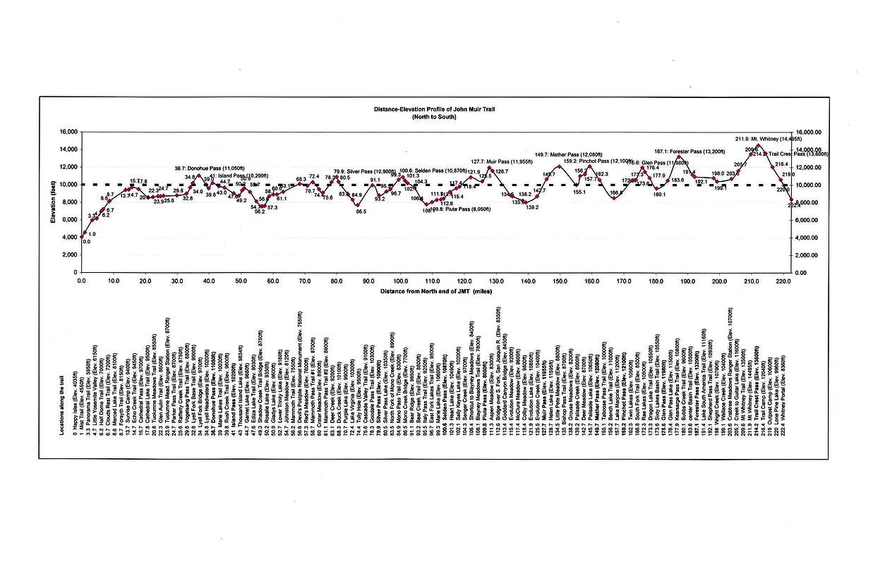
Another thing we worried about was the altitude of the John Muir Trail. As the elevation profile shows, the trail starts at 4,000 feet and rises quickly. By the second day, we would be above 10,000 feet. After that the trail would alternate between roughly 8,000 and 12,000 feet until the end, when it would rise to 13,200 feet in Forester Pass and 14,500 feet on Mt. Whitney. Unfortunately, there was little we could do to prepare for the altitude other than pack several rolls of Tums.
Getting to the Start
I ended up needing to go to San Jose on a business trip a week before the start of our hike, so I flew to San Jose a week ahead of the others. Melanie, Michael and Danielle were scheduled to fly out of Boston early in the morning on June 30th. Melanie was on one flight, and Michael and Danielle were on another. When they arrived at the airport, they found that Michael and Danielle’s flight had been delayed for several hours due to mechanical issues. It looked like the earliest they would be able to get to San Jose would be late in the evening. This would have made it very difficult for us to start our hike on the next day, as required by our permit. After some desperate conversations with airline personnel, Melanie managed to get Michael and Danielle on a direct flight to San Francisco that arrived at 9:45 a.m. I picked up the rental car in San Jose and drove to San Francisco and picked them up. We then drove back to San Jose and picked up Melanie.
As we drove from San Jose to Merced, the reality of what we were about to undertake was looming large in our minds. Our plan was to spend the night in the backpackers camp in Yosemite Valley, but we began to have a strong desire to postpone sleeping on the ground for one more night. Melanie got on the phone and started searching for better accommodations. It was last minute, but she found a platform tent in the park’s Curry Village with beds for four. They wanted $160 a night for it. $160 for one night in a tent with a public bathroom and showers? Outrageous! We booked it. We were that desperate.
We arrived at the Merced Airport around 4 p.m. and dropped off the rental car. While we were waiting for the YARTS bus that would take us into the park, a small aircraft landed and about ten passengers got off. One of the passengers was headed to Yosemite. When the bus driver picked us up, he said he hadn’t picked anyone up at that stop in months. Apparently, this is not how most people get to Yosemite.

The bus ride into the park took about two hours. We arrived around dusk. Curry Village turned out to be a city of about 1,000 platform tents like the one we had reserved. We got set up in our tent and then stood in line for pizza for about an hour. It seemed very ironic to be starting our wilderness hike from a place where so many people were packed into such a small area with so little physical separation. To Melanie, it felt like being in Disneyland. We were very happy, however, to have beds to sleep on and a place to organize our gear.

The next morning, I walked about a mile to the Yosemite Valley Wilderness Center where I picked up our wilderness permit and rented our bear canisters. The ranger who helped me told me there was an especially aggressive bear in Lyell Canyon that had torn up some camps. When I asked him how far away from our tent we should place our bear canisters, he said 20 feet. I was surprised; I thought they should be about 100 yards away. He explained that the canisters were bear-resistant, not bear-proof, and that we should defend them. If a bear came, he said we should jump out of the tent, make a lot of noise, and chase the bear away. He said it was fun.
On the wall behind the ranger was a whiteboard with the weather forecast for the day. The high temperature was projected to be 106º at 4,000 feet, the elevation of Yosemite Valley. Thunder storms were forecast for the afternoon. The ranger said we should expect afternoon storms for the next few days.
On my walk back to Curry Village, I saw a deer that people were photographing from a distance of about 20 feet.
Back at our tent, we finished packing and then caught the shuttle for the short ride to the Happy Isles trailhead. After months of planning and training, we had finally arrived at the start of the John Muir Trail. It was about 10 a.m. on July 1st.
The Pain
Prior to setting foot on the John Muir Trail, the only backpacking trips Melanie, Michael and Danielle had taken were the practice hikes we had done in preparation for our JMT hike. Practice hikes and physical training help, but they are almost always insufficient to prepare for the stresses of carrying a heavy pack many miles a day, day after day. Generally it takes about two weeks for the body to adjust. In our case, our entire hike was only two weeks, so we were destined to experience a significant amount of discomfort throughout the hike. I knew this from my Appalachian Trail hike, and I told everyone the hike would be hard. In spite of this, we all greatly underestimated how hard it would be.
The climb out of Yosemite Valley was very hot. There was an afternoon thunderstorm, as forecast, but it was short and brought welcome relief from the high temperatures. We were not so lucky on the next two days. On the second day of the hike, there was an early afternoon storm that lasted much longer and soaked us through. On our third day, we got caught in a violent storm in Donahue Pass that pelted us with quarter-inch hail. The storm lasted a long time. We were soaked and very cold by the time it ended. Unfortunately, the video that Michael took with Danielle’s GoPro doesn’t come close to capturing the strength of the storm.
Melanie, Michael, and Danielle all developed blisters during the first days of the hike. The best treatment seemed to be to wrap them with medical tape, but the blisters still grew and multiplied as the days went by. Ibuprofen (Vitamin I, as the PCT thru hikers called it) provided some short term relief, but their blisters were very painful throughout the entire hike.
In addition to the blisters, Danielle had trouble with her knees. Walking downhill became very slow and painful for her. Fortunately, Melanie discovered a way to walk downhill that put a lot less strain on her knees. She would shuffle (almost jog) downhill. After adopting this technique, she was often the fastest in our group on the descents. She shared her technique with Danielle, and Danielle’s knees stopped bothering her within a day or so.

The altitude affected us all, some to a greater extent than others. We all had a day or two where we got nosebleeds. These were a nuisance, but they didn’t slow us down. The thin air, however, slowed everyone down. In particular, it seemed that everyone had less energy on the days following nights spent at or above 10,000 feet. We tried to camp as low as possible, but our schedule didn’t give us a lot of flexibility.

Michael felt the effects of the altitude on our first day, but he was strong after that, often carrying extra weight with his substandard pack. Melanie suffered the most from the altitude. She was very nauseous for most of the second day of the hike, and she had periodic bouts of nausea throughout the hike. She kept the Tums close at hand and went through several rolls. Even when she wasn’t feeling nauseous, she often found the climbs to the high altitude passes very difficult. At times, each step required great physical and mental effort.
In the end, the training that proved most effective for avoiding blisters, sore knees and altitude issues, was the training I did to prepare for my 100 mile race. In the months leading up to the hike, I had spent ten to fifteen hours a week running in the mountains and hills around our home. This paid off on the hike. I had no blisters or knee problems, and I only had minor dizziness and nosebleeds from the altitude. But even with this much training, I was still exhausted and very sore at the end of every day.
In an essay about the hike, Danielle wrote:
We walked fifteen miles on blistered feet, endured ten hours with heavy packs sitting on bruised hips. And ate “just add boiling water” meals…for fifteen days. Each morning, as I began to gain consciousness, I’d assess the level of discomfort I was about to face. My skin was always clammy from the recycled air of a tent, my muscles sore, my joints stiff as hell, and my neck contorted with weird knots from using my fleece as a makeshift pillow. And when my eyes opened to see only a zippered door shielding me from the fifteen miles awaiting my destroyed body, I’d ask myself, “Why the hell am I doing this?”
Funny question. I was the instigator after all, the mastermind of this whole excursion. It was my idea, my graduation present at that. It was my graduation present to walk fifteen miles a day on a blister big enough to qualify as a sixth toe. It was all I could do to keep my head down and watch one foot miraculously surpass the other, over and over again.
Most of the JMT thru hikers we met on the trail were allowing about three weeks to complete the hike. To finish in three weeks, they had to average about ten miles per day. This is a much more reasonable pace than the fifteen miles per day we averaged. At ten miles per day, you have time to stop and rest and enjoy the scenery. At fifteen miles per day, you have to keep moving. We generally took only three breaks a day: one mid-morning, a longer break for lunch, and one mid-afternoon. We often ended up hiking until 7 or 8 p.m., and the last few miles of the day were almost always a slog.
When we finally made it to camp at night, we were all spent. I generally had the fewest ailments, so I did many of the camp chores. My last chore of the day was to make sure all the food was in the bear canisters. I followed the ranger’s instructions and placed the canisters about 20 feet from the door of our tent.
I found that spending the final minutes of the day thinking about the possibility of a bear coming into our camp was not very conducive to getting a good night’s rest. I slept very little on the first few nights. On at least two nights during the hike, I woke up thinking I had heard a bear, ripped open the door of the tent and start shouting. There was never a bear, however. The only thing that ever disturbed our camp was me and my shouting.
Toward the end of our hike, we met a man named Scott Chandler who has been hiking in the Sierra Nevada for many years. Scott has a blog with backpacking information and some amazing photos of the Sierra Nevada. He posted one photo that, unlike the pictures we took, puts us in proper perspective relative to the surrounding landscape. One of the many interesting things we learned from Scott was that the number of bear incidents in the parks dropped significantly after the parks began requiring backpackers to store food in bear canisters. The National Park Service page on bear facts reports that there were 155 bear incidents in Yosemite National Park in 2012, which was down 82% from 1998.
But while bear incidents were down, bug incidents were not. We were repeatedly attacked by swarms of mosquitoes during our hike. I had read that the mosquitoes can be bad in places along the Muir trail, but I discounted the warnings: the mosquitoes couldn’t possibly be worse than they are in New England. Well, they were worse–much worse. Fortunately, the 95% DEET insect repellant we brought with us did a good job of keeping them at bay. Michael, however, seemed to prefer to let the bugs feast on him. We would call out: “Hey Mike, you have a bunch of mosquitoes on the back of your leg.” He would just grumble and march on, annoyed at us for bringing them to his attention and for expecting him to do something about them.
Such were the hardships that we encountered on the John Muir Trail. Sometimes they were so numerous and arduous that we just needed to block them out. At other times, we coped by imagining there was some higher purpose to our suffering. One thing is certain, however: if people could hike through the beautiful wilderness areas of the parks without experiencing hardship, many more people would do it. More people would mean fewer opportunities to experience the solitude of the wilderness and more damage to the beautiful landscape. Therefore, I like to think of the blisters, bruises, bloody noses, blood-sucking bugs and bears as important parts of the system that helps protect the beauty of the Sierra Nevada.
The Beauty
The portion of the Sierra Nevada that is revealed by the John Muir Trail defies description. No words or images can do it justice. As hikers, we didn’t just see the grandeur; we experienced it with all of our senses and with our entire bodies. Where our camera captured a still image of Nevada Falls in Yosemite, we saw the water move through space and time. We heard it roar as it was pulled through the air and over rock by the earth’s gravity. We felt the power of that gravity as we labored against it to climb above the falls. We smelled the rich aromas of the surrounding trees and plants as we drew the pristine mountain air deep into our lungs. When we reached the river above the falls, we saw its water was so clear that it left the fish no place to hide. We tasted how pure the water was when we quenched our thirst with it, and its ice cold temperature reminded us that it had recently been part of the brilliant white snow fields high above us.

As we hiked past Yosemite’s water falls and exfoliating granite domes, I could not imagine that anything could be more beautiful. As Half Dome receded behind us, I wondered if we had already seen the best that the John Muir Trail had to offer. I did not need to worry; the beauty seemed to increase as the trail guided us deeper into the wilderness. There were lush green meadows with deer grazing at dusk; ancient, towering trees; countless species of flowers and plants; unearthly, barren landscapes; emerald green lakes; and cloudless, sunlit skies, so dark blue, they were almost black. And above all, there were the majestic mountains and the passes through them.
The high mountain passes were breathtaking–both figuratively and literally. The climbs to reach them were almost always long and difficult. As we climbed, we would gradually see more and more of what lay behind us, and less and less of what lay ahead. Often we could only see a dozen or so yards ahead as we approached a pass. Then, almost in an instant, the vast wilderness beyond the pass would come into view. The transitions were stunning. From some of the passes, we could stand in one spot and see for twenty to thirty miles in both directions. It was in places like this, with our aching feet, our exhausted legs, and our oxygen-starved lungs that we experienced the remoteness and magnitude and beauty of the Sierra Nevada most keenly.
There were, of course, many times during the hike when the negatives exceeded the positives. During these times, our thoughts and discussion would often turn to our end goal, Mt. Whitney. This goal kept us going when things were tough. Without it, we would have ended our hike earlier and missed many incredible things, including Mt. Whitney. In her essay on the hike, Danielle wrote:
One would think that two weeks of living amongst impressive peaks, meadows, and rivers would warrant some form of transcending, inspiring realizations, or maybe even some self-discovery. But for two weeks all I thought about were burgers, showers, sundresses, and flight attendants serving me ginger-ale while my sore ass enjoyed a cushioned seat. Most of all though, I thought about Mt. Whitney.
My dad called it “Whitney Fever.” Said he had experienced “Katahdin Fever” when he hiked the Appalachian Trail. For me, on the John Muir Trail, it was Whitney that I obsessed over. Getting there, climbing it, summiting, being done with all this nonsense.
Danielle and Michael began planning our ascent of Mt. Whitney during the first few days of our hike. They wanted to reach the summit at sunrise. It was no surprise to Melanie and me that Danielle wanted to do this. Danielle is very fond of watching the sunrise from the top of a mountain near our home. Many times she has gotten up early in the morning, hiked up the mountain by herself, watched the sunrise, and then hiked down and gone to school. Several times she left the house at night, hiked up the mountain in the dark, and camped out by herself on the summit overnight.
Thanks to Danielle and Michael’s plan to be on the summit of Mt. Whitney at sunrise, we spent the last night of our hike camped at 13,500 feet, two miles from the summit of Mt. Whitney. Michael had hiked ahead that day and staked our claim to the tent site. We will never forget that evening. The views and the sunset were incredible. What we saw that evening was, by itself, worth the 209 miles we had hiked to get there. Danielle wrote:
The evening of our 14th day, we camped a mile and a half from the top of Mt. Whitney, as planned. After getting our tent settled into a site above the switchbacks, I used our last bit of propane to boil water for a cup of tea. It seemed fitting, wrapped in my sleeping bag, looking out from our perch at 13,500 feet. I cradled the stove and tentatively placed my lips to its edge. The steam bit at my cold nose and forced my eyes to close. I opened them to limitless mountain peaks, standing in serrated rows, rigid and unchanged by the awe they demanded. The sun sat low in the sky and the Sierras painted their jagged faces with its light. The switchbacks wrinkled the mountain face and my eyes followed them as they descended towards the lakes sitting like spilt ink blots below. Along the lakes, trees freckled the elevation line they found compatible, until joining into a mass of vast wilderness.
What a beautiful place to wander.

The next morning we got up at 3:30 a.m. and hiked the final two miles to the summit. The grade was not steep, but the climb was difficult. Even after two weeks on the trail, the altitude was still a challenge. We arrived at the summit just before sunrise, a little less than fourteen days from when we had started. It was bitter cold. We climbed into our sleeping bags and watched the sun peek over the horizon as wisps of white clouds blew over the mountain around us. We could not have asked for a more perfect finale to our trip.

The Return to Civilization
One thing we overlooked when planning our hike, was that the eleven miles from the summit of Mt. Whitney to Whitney Portal were not part of the official trail. As a result, our hike was actually 222 miles, not 211. We realized this early on and accounted for it in our daily mileage goals, but as we stood on the summit of Mt. Whitney, we still had nearly a full day’s distance ahead of us. It helped, however, that it was all downhill, and that there were burgers and fries to be had at Whitney Portal. Danielle flew down the mountain with Michael in hot pursuit. Melanie and I followed as quickly as we could.
On our hike down, we passed a steady stream of hikers going up. We saw more people on the eleven miles from the Mt. Whitney summit to Whitney Portal than we had seen during the last ten days on the trail. Some of the people we passed mentioned seeing Danielle and commented on how eager she had been to get to Whitney Portal.
When Melanie and I finally reached the end of the trail and its infamous, endless switchbacks, Danielle and Michael were almost done with their burgers and fries. Melanie and I ordered food, and Melanie phoned the shuttle service. We were still eating when Bob, the owner of the shuttle service, arrived to pick us up.
On the ride down to Lone Pine, Bob shared with us some of the history of the movies that have been shot in and around Lone Pine. He said the scene in Iron Man where Tony Stark demonstrates the Jericho missile (supposedly in Afghanistan) was shot with the Sierra Nevada and Mount Whitney as the backdrop.
When Bob dropped us off at our hotel in Lone Pine, the temperature was well over 100 degrees. It was hard to believe that we had been in freezing temperatures just a few hours earlier. We did laundry and showered off ten days worth of trail grime. Then we began looking for more food. Unfortunately, our hotel was a mile out of town, and there were no taxis or buses in Lone Pine. It was strange, but somehow a one mile walk over flat ground with no packs had suddenly become a big obstacle. We waited until early evening, when it had cooled off a bit, and then made the trek down to the local pizza joint.
Early the next morning, we did the hike into town one more time and caught the Sierra Transit Authority bus north. There were some other hikers on the bus who we had met the day before in Forester Pass, including a couple who had hiked the trail from Tuolomne Meadows to Whitney Portal with their young daughter who was around nine years old. They had hiked a total distance of about 200 miles with her.
In Mammoth we rented a car and drove back to San Jose through Yosemite on the Tioga Pass Road. On the way, we stopped briefly in Tuolomne Meadows where we had done our first resupply. The family we had seen on the bus was there, along with a number of hikers who were picking up their resupply packages. We would have liked to have stayed and visited for a while, but Michael and Danielle had a plane to catch. So we hurried off, back to ginger ale and cushioned seats.
Epilogue
On one of the many trips I made to Eastern Mountain Sports before our hike, the young woman who was helping me told me about the Ken Burns, Dayton Duncan series, The National Parks: America’s Best Idea. I didn’t have time to watch the series before our hike, but Melanie and I watched it when we came home. Our eyes welled up as we listened to the stories of what John Muir, Theodore Roosevelt, Stephen Mather, Harold Ickes, Ansel Adams, Franklin Roosevelt and others had done to preserve the places where we had hiked. The story of how Kings Canyon National Park was created was especially moving. President Franklin Roosevelt, who signed the bill that created the park, was never able to visit it because of his disability and the fact that there were no roads through the park.
Kings Canyon National Park is the most remote place I have ever been. It took us six days to hike across it. During those six days and the day that followed, we saw almost nothing that had been made by man. We were totally immersed in the unadulterated grandeur of the Sierra Nevada. I cannot begin to describe the emotional impact of the experience, but the following photograph of Danielle standing on the western face of Mt. Whitney provides a glimpse of its powerful effect.

There was, however, a downside to spending so many days immersed in beauty without seeing hardly a thing that had been created by man: since returning home, I have been struck by how unattractive–even ugly–most human creations are compared to what they displace in nature. This ugliness, which had previously been invisible to me, now seems ubiquitous.
After seeing the Grand Canyon, President Theodore Roosevelt said:
I want to ask you to keep this great wonder of nature as it now is. I hope you will not have a building of any kind, not a summer cottage, a hotel or anything else, to mar the wonderful grandeur, the sublimity, the great loneliness and beauty of the canyon. Leave it as it is. You cannot improve on it. The ages have been at work on it, and man can only mar it.
The Sierra Nevada is another such wonder of nature. It is a place that man can only mar. May we always keep it as it now is.
Photographs
Click to enlarge any photograph (both those above and those below)


Hi Bill,
I just finished reading 14 Days of Pain and Beauty. Thanks for posting that! I enjoy your writing style but must admit that I found the excerpts from Danielle’s report especially moving. That girl has some writing talent!
Anyway, good luck with all future endeavours and say hello to the family for me.
Viele Liebe Grüße aus Deutschland!
Andrew McGuire
p.s.
I posted by mistake under “About”. Please excuse, it is my first day on the internet. : )